Featured Projects

Other Landscape Planning and Assessment Projects
Strategic Assessment
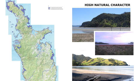
Otorohanga District Landscape Assessment (Otorohanga, 2009 - 11): identification of Outstanding Natural Features and Landscapes, Amenity Landscapes and parts of the District’s coastline - together with lake and river / stream margins - that display high Natural Character values - for Otorohanga District Council.
Manawatu / Tararua / Lower Rangitikei District Landscape Assessment (2009): identification of the Outstanding Natural Landscapes and Amenity Landscapes distributed within all three districts within 150km of the Turotea Wind Farm site in the northern Tararua Range - for Mighty River Power.
Kawhia Aotea West Coast Assessment (2006): assessment of the landscape and natural character values of the catchments around Kawhia and Aotea Harbours, including the identification of the area’s outstanding landscapes, visual amenity landscapes and parts of the coastline displaying high natural character - for Environment Waikato and the Waikato, Waipa and Otorohonga District Councils.
Whangarei District Landscape Review / Assessment (2005): assessment of landscape values across Whangarei District to identify its Outstanding Landscape and Visual Amenity Landscapes, involving use of past public preference research, public consultation, identification of natural character values, landscape heritage values - in conjunction with Beca Carter Hollings & Ferner Ltd for Whangarei District Council.
Assessment of the Auckland Region's Landscape (2001-4): responsible for a review of landscape assessment methodologies appropriate for re-assessment of the Auckland Region's landscape, including literature search and organisation of workshops to review theoretical options - designed to address identification of Auckland's outstanding / iconic landscapes; followed by Q-Sort testing of public attitudes to landscape, and mapping of the Auckland Region’s Outstanding Landscapes - for the Auckland Regional Council.
Hauraki Gulf Islands District Plan - Plan Change Reviews (2003): detailed reviews of Plan Changes 23 (Subdivision), 24 (Earthworks), 25 (Indigenous Vegetation Clearance) & 26 (Lot Coverage) involving detailed assessment of the Waiheke and Great Barrier Island landscapes in respect of their capacity to accommodate changes to the relevant thresholds for permitted and discretionary activities and assessment criteria leading to recommendations in relation to each Plan Change - for Auckland City.
Auckland Urban Coastline Assessment, Waiheke Island Coastal Landscape Assessment, Great Barrier Island Coastal Landscape Assessment (1993-5): Assessment of the VALUE, VULNERABILITY and overall SENSITIVITY of each of these coastal areas - involving their breakdown into landscape units, description and discussion of landscape character types and preparation of preliminary policies for landscape management - for the Auckland Regional Council.
Hawkes Bay Regional Landscape Assessment, East Manukau Assessment (1994-6): responsible for managing / overseeing assessment of the landscape values in each of these strategic landscape studies - involving their breakdown into landscape units, description and discussion of landscape character types and preparation of preliminary policies for landscape management - for the Hawkes Bay Regional Council & Manukau City Council.
Mahia Peninsula / Wairoa Coastal Strategy (2003): assessment of the landscape and natural character values of the Mahia Peninsula and nearby coastal areas, including Mahanga and Opoutama, to provide input on both conservation and strategic development strategies for the Wairoa District Coastal Strategy Study - for Beca Carter Hollings & Ferner and Wairoa District Council.
North Shore City Significant Landscape Features Assessment (1998-2001): identification, analysis and description of all significant landscape features within the Albany, Greenhithe, Paremoremo and Long Bay / Okura parts of North Shore City - for North Shore City Council.
East Tamaki Catchment Management Study (2001): analysis of landscape and open space values in the East Tamaki catchment leading to recommendations in relation to future open space provision and park acquisition - for Beca Carter & Manukau City Council.
Whangarei District Coastal Management Study (2003): assessment of the landscape values and ‘carrying capacity’ of settlement areas down the eastern Whangarei coastline leading to recommendations about future development and conservation strategies - in relation to: Oakura, Moureeses Bay, Woolleys Bay, Matapouri, Pataua South & North, Ocean Beach, Urquharts Bay, Taurikura, Reotahi and McLeods Bay - for Beca Carter & Whangarei District Council.
Waitakere City Northern Strategic Growth Area Study (2000 - 2001 & 2003): Analysis of existing landscape features, character areas and resources within the Whenuapai / Hobsonville / Brighams Creek catchment as the basis for evaluation of future growth options. This work includes the identification of key landscape sensitivities within the catchment, the identification of development constraints and opportunities in relation to the local landscape and the preliminary assessment of effects associated with shifting Auckland's MUL in the subject area - for URS New Zealand Ltd and Waitakere City Council (Eco Water). In 2003 this work was extended to cover Herald Island and the Red Hills area - for Landcare Research.
Franklin District Rural Plan Change Study: responsible for re-evaluating most of Franklin District - in relation to landscape values, sensitivities and residential development potential / appeal - to determine areas that present opportunities for residential growth, rural areas that should be specifically excluded from rural-residential development and generic features that should be conserved throughout the District - for Franklin District Council.
Volcanic Cone Sightlines Review (1997 - 2003): appraisal of current sightlines to Auckland’s volcanic cones leading to suggestions about the addition, deletion and location of sightlines, and the specification of controls in relation to each - for the ARC and Auckland City Council.
Whangarei District North-eastern Coastal Settlements Assessment (1996): assessment of key landscape features and elements that should be conserved to help define the margins of urban growth around Whangarei District's north-eastern coastline - from Ocean Beach in the south to Oakura and Whangaruru - for Whangarei District Council.
Assessment of the Auckland Region's Landscape (1983-4): region-wide appraisal of both the aesthetic quality and the visual absorption capability of different parts of Auckland's extra-urban landscape (covering 425,000 has). This study involved breaking the Region down into 633 landscape units and incorporated a public preference study with over 1100 public participants. It has enabled planners to come to terms with both public perceptions of landscape value and the relative vulnerability of different parts of the Region to development - for the ARC.
Project Impact Assessments
Hagley Park Cricket Oval Application (2013) - review of the landscape and amenity effects of a proposed cricket oval - including embankments, spectator pavilionsand seating, light towers, security fencing and parking - within Hagley Park South for events up to the international level - for Christchurch City Council.
Hahei Structure Plan, Coromandel (2013) - evaluation of landscape and amenity implications of a proposed subdivision at Hahei.
Bull Creek, Dunedin (2013) - evaluation of natural character and amenity implications of a proposed subdivision on coastal terraces at Bull Creek.
Tairua Harbour Estuarine Management Review (2013) - evaluation of the landscape, natural character and amenity implications of undertaking estuarine management in the Tairua Harbour including the removal of mangrove stands for Waikato Regional Council.
Sandspit Marina Application (2012) - peer review of the landscape, natural character and amenity effects of a proposed marina within the Matakana River estuary - for Auckland Council
Escarpment Mine Appeals (2012) - review of the application for the Escarpment Mine proposal on the Denniston Plateau and presenttaion of evidence at the Environment Court - for Buller District Council.
Seafarers Site Redevelopment - Quay St (2012) - review of the visual and urban design implications of a proposed plan change by Coopper & Co to accommodate 55m high hotel / commercial developent on Auckland’s waterfront, at the edge of the Britomart Jreitage Precinct - for Auckland Council
Erin Street Netball & Tennis Courts, Auckland (2012) - evaluation of landscape and amenity effects for a proposed netball and tennis court facility. The facility included five 10m high light poles, 3m high mesh fencing, and a pavilion which was located in a residential 6a neighbourhood.
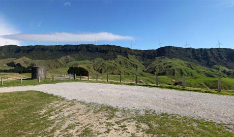
Project Mill Creek (2010): assessment of the landscape, natural character and amenity effects of a proposed 31 turbine wind farm proposed in close proximity to Makara and Ohariu Valley, near Wellington - for Wellington City Council
Moorabool Wind Farm (2009/10): assessment of the landscape and amenity implications of a proposed 110 turbine wind farm east of Ballarat in the Moorabool Shire of Victoria - for WestWind Pty Ltd.
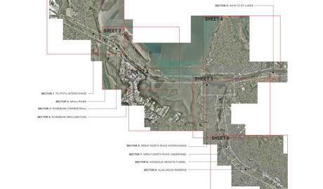
Waterview Connection Project / SH16 (2009): assessment of landscape, amenity and natural character effects associated with redevelopment of the Te Atatu - Waterview section of Auckland’s North-western Motorway and the Te Atatu interchange - for the NZ Transport Agency
Project Central Wind (2009): evaluation of the landscape, natural character and amenity effects of a proposed 51 turbine wind farm proposed for the southern margins of the North Island’s Volcanic Plateau near Taihape and SH1, including a sub-regional assessment of alternative locations - for Meridian Energy Ltd
Allandale Wind Farm (2008): evaluation of the landscape and amenity effects of a proposed 50 turbine wind farm near Mt Gambier and Port MacDonnell in South Australia - for Acciona Ltd
Sidonia Hills Wind Farm (2008): assessment of the landscape and amenity implications of a proposed 52 turbine wind farm in the Macedon Hills Shire of Victoria - for Hydro Tasmania Consulting & Roaring 40s.
Eden Park 2011 (2006 - 9): detailed evaluation of the amenity and landscape effects of the proposed redevelopment of the Eden Park stadium and grounds for the Rugby World Cup 2011, addressing both ‘legacy’ and temporary stand alternatives - for the Eden Park Redevelopment Board
Project West Wind (2006): assessment of the strategic, regional implications, of the Project West Wind wind farm relative to the Wellington region and the southern halves of the Wairarapa and Manawatu coastlines - for the NZ Wind Energy Association
Turitea Wind Farm (2006 - 10): preliminary assessment of the landscape and amenity effects of a proposed 80 turbine wind farm on the Tararua Ranges near Palmerston North - for Might River Power
Awhitu Wind Farm (2005): evaluation of the strategic landscape and natural character effects of a 21 turbine wind farm proposed by Genesis Energy for the coastal margins of the Tasman Sea and Awhitu Peninsula near Waiuku, south of Auckland - for the Auckland Regional Council
Coca Cola Amatil Plant Expansion (2005): assessment of the amenity effects associated with an $80 million expansion of Coca Cola Amatil’s plant at Mt Wellington, abutting two arterial roads and a large residential community - for Coca Cola Amatil.
Glenfield Rd Designations Review (2004): review of the effects of implementation of three Outline Plans Of Work and resource consent applications related to the widening of Glenfield Rd, an arterial route within North Shore City, including evaluation of impacts in respect of amenity, streetscape and open space values - for North Shore City.
Matiatia Village (2003-4): evaluation of he landscape, natural character and amenity effects associated with a comprehensive commercial village development (18,000m2), together with car parking and transport interchange at the ‘gateway’ to Waiheke Island - for Waitemata Infrastructure Ltd.
Waitemata Harbour Crossing Options Assessment (2002-3): Evaluation of the visual and amenity effects of 9 harbour crossing options, including bridges, tunnels, submerged tubes, reclamations, ventilation and service structures, trenches and motorway interchanges - for Opus International and Transit NZ
Lake Rd Designations Assessment (2002): detailed analysis of the effects associated with widening of Lake Rd, including impacts upon residential amenity, streetscape and open space values; and appraisal of mitigation measures - for North Shore City.
Omokoroa Roading Options Study (2001): evaluation of route options and effects as part of an Assessment of Environmental Effects (in association with Beca Carter Tauranga) - for Western bay of Plenty D. C.
Tauranga Northern Arterial Review & Arbitration (2000): evaluation of the proposed northern arterial's implications utilising assessments prepared by LA4 and Priest Mansergh, followed by site visits, and provision of recommendations to Transit NZ, the Bay of Plenty Regional Council and Western Bay of Plenty District Council about the landscape mitigation measures that should be employed in conjunction with development of the arterial corridor - for Transit NZ, the BOP Regional Council and WBOP District Council.
Dominion Rd Transport Designation Assessment (2000): detailed analysis of the amenity and visual implications of proposed transport corridor designations, including road widening and LRT corridor deviations off Dominion Rd - for Auckland City.
Weiti River Crossing Review (2000): review of the effects of a proposed bridge over the Weiti Estuary and the coastal environment - for the Auckland Regional Council.
ALPURT B2 Waiwera River Crossing Review (1999): review of the effects of a proposed bridge and related roading developments on the Waiwera and Puhoi Estuary coastal environs - for the Auckland Regional Council.
Sylvia Park Commercial Centre Assessment (1999): detailed assessment of the implications of a plan change to accommodate 150,000 sq metres of retail, office, and residential development at Mt Wellington, including community facilities, a railway station and new access road - for Kiwi Property Management Ltd.
Marsden Point Port Impact Assessment (1997 & 2002): responsible for assessment of the visual and amenity implications of a major new port facility covering some 37 hectares and associated infrastructure development - including preparation of proposals for amelioration & enhancement around Blacksmith's Creek, followed by assessment of the effects of additional berths in 2002 - for the Northland Port Corporation / Northport.
Eastcliffe On Orakei (Bastion Point) Housing Project Assessment: analysis of the visual and amenity implication of an 86 unit housing development next to Takaparawha reserve at Bastion Point & development of landscape concepts / detailing as part of the overall development proposal - for Protac Investments & Ngati Whatua.
Spencer On Byron Hotel (1998): assessment of the visual effects of a 22 storey hotel proposal for Byron Ave in Takapuna - for Manawanui Trust.
St Josephs Convent Redevelopment Assessment (1995-6; 2001): analysis of the visual implications of replacing an existing convent with a combined retirement home / convent / chapel in St Marys Bay, including development of landscape concept for the main grounds and courtyards - for Little Sisters of the Poor.
Brightside Hospital Assessment (1995-6): analysis of the visual and amenity implications of replacing an existing hospital with a new hospital facility in central Epsom, including development of landscape proposals for the historic grounds - for Southern Cross.
North Harbour Gas Pipeline (1995-6): three stages of involvement in the planning process covering: evaluation of broad ‘corridor’ options for routing of the pipeline and identification of three preferred routes; detailed assessment of the landscape and amenity implications of the preferred route option; and preparation and presentation of evidence about the proposal and its effects for the North Shore City Council hearing - for Enerco.
Southdown Power Station Assessment (1995): detailed assessment of the likely visual and amenity implications of a co-generation power station within the industrial/coastal environment of Southdown - for Mercury Energy / Transalta.
South-western Interceptor Assessments (1992; 1996-7): detailed assessment of the proposed route for the South-western Interceptor AEE - covering a route from Homai Stream to Puhinui Rd (the eastern airport Access road) via the Matukutururu Stonefields, Puhinui Inlet and Puhinui Reserve - for the AEE. Followed up in late 1996 with development of an amelioration strategy - for WaterCare Services Ltd
Sky Tower Assessment (1991): assessment of the Sky Tower proposal for upper Symonds St, Grafton, and presentation of evidence at the Planning Tribunal in relation to its effects - for Auckland City Council & the Auckland Regional Council.
Auckland International Airport Eastern Accessway Impact Assessment (1989 / 1991): appraisal of a new entry route and bridge options across Pukaki Inlet for Mangere International Airport and development of broad guidelines for the design of the entry road and its immediate surrounds - for the Auckland International Airport Company Ltd.
A.R.C. Reservoir / Bulk Water Supply Options Study (1988): responsible for detailed evaluation of eight different dam and/or river extraction options for supplying Auckland with water into the 21st century - for the Water Dept of the Auckland Regional Authority.
Channel Tunnel Railway Connections Study (1986): evaluation of route options and landscape impacts associated with provision of railway connections to the Channel Tunnel immediately north-west of Folkestone - for the United Kingdom Department of Transport.
Site Selection Studies for P.W.R. Stations at Trawsfynydd and Wylfa - North Wales (1984-6): evaluation of a wide range of different siting options for two power stations proposed for North Wales based on landscape/visual impact criteria - for the (U.K.) Central Electricity Generating
Peer Reviews of Impact Assessments
Escarpment Mine Application (2012): peer review of the landscape, amenity and natural character effects of the proposed Escarpment Mine (open Cast) on the Denniston Plateau, including detailed review of whether or not the Plateau lies within an Outstanding Natural Landscape; followed by the preparation and presentation of evidence at an environment court hearing - for Buller District Council
Onehunga Foreshore Restoration Project (2011): peer review of the evaluation of landscape, natural character, amenity and urban design effects associated with rehabilitation of the Onehunga foreshore - for Auckland Council.
Matiatia Marina Project (2011 - 2013): review of the landscape, natural character and amenity effects of a proposed marina within Matiatia May at the western gateway to Waiheke Island - for Auckland Council.
Orakei Point (2008): peer review of a mixed use residential / commercial / transport hub development on the edge of the Orakei Basin and Hobson Bay in Auckland, involving up to 8 storey development and footprint of up to 88,000m2 of residential floor space, together with another 20,000m2 of commercial floor area, in conjunction with creation of a pedestrian plaza and recreation areas on the edge of both water areas - for the Auckland Regional Council.
Waikato Wind Farm Project (2008): review of the landscape, natural character and amenity implications of a 235 turbine wind farm proposed for the Tasman Sea’s coastal hinterland between Port Waikato and Raglan, covering a site some 34kms long and up to 8kms wide - for the Waikato and Franklin District Councils.
Te Uku Wind Park (2007): peer review and assessment of the landscape, amenity and natural character effects of a 28 turbine wind farm proposed for the Te Uku Ridge / Wharauroa Plateau by WEL Networks - for Waikato District Council.
Te Arai Coastal Community Review (2005 - 2006): evaluation of the landscape and natural character effects of a proposed 1400 lot development at northern Pakiri Beach (north-eastern Rodney District), incorporating a commercial / community centre, golf course, wetlands / lakes and coastal reserve - for the Auckland Regional Council.
St Emilion Comprehensive Housing Development (2005 - 2006): evaluation of the landscape and amenity implications of a ‘gated community housing project, containing 144 residential units and a recreation centre - for Rodney District Council.
Swanson Structure Plan (2005): analysis and review of Waitakere City’s proposed Swanson Structure Plan for an area on the margins of both metropolitan Auckland and the Waitakere Ranges, as the basis for an Environment Court Appeal - for the Auckland Regional Council.
Project West Wind (2005): detailed peer review of the West Wind proposal and Peter Rough Associates’ assessment of the proposal’s landscape and visual effects - for Meridian Energy Ltd.
Millbrook Quarry Review (2005): assessment of the landscape effects of a proposed 30 year expansion to the current Wharehine Quarry near Mt Tamahunga and southern Pakiri (north-eastern Rodney District) - for Rodney District Council.
Awhitu Wind Farm (2004 - 2005): evaluation of the strategic landscape and natural character effects of Genesis Energy’s proposed wind farm at the southern end of the Awhitu Peninsula - for the Auckland Regional Council.
Mountain Landing Coastal Residential development (2004-5): assessment of the landscape effects of a proposed 40 lot subdivision, involving extensive ecological restoration, next to Marsden Cross in the northern Bay Of Islands - for Blue Water Holdings and The Environmental Defence Society.
Tairua Marina (2002 - 5): review of the natural character, landscape and amenity effects of a proposed marina (150 berths) at Tairua on the Coromandel Peninsula, as the basis for hearing recommendations, then appeal evidence - for Environment Waikato,
Tairua Marina (2002- 3): detailed review / analysis of the natural character implications of three marina proposals for Tairua Harbour and recommendations - for Environment Waikato.
277 Broadway Review (2002-3): responsible for reviewing the visual and urban design components of proposal for the redevelopment of the "277" sites in Newmarket - for City Planning.
Telstra Clear Telecommunications Network Review (2002): evaluation of the assessments undertaken as part of 4 applications for the staged 'roll out' of an overhead cable network within Auckland City - for Auckland City Council.
Weiti River Crossing Review (2000): review of the effects of a proposed motorway bridge over the Weiti Estuary and the coastal environment - for the Auckland Regional Council.
ALPURT B2 Waiwera River Crossing Review (1999): review of the effects of a proposed bridge and related roading developments on the Waiwera and Puhoi Estuary coastal environs - for the Auckland Regional Council.
O'Shea Subdivision Review - Great Barrier Island (1999 - 2000): evaluation of a proposal for a 17 lot subdivision at Awana on the basis of protection of a Special Environmental Feature leading to participation in the Council hearing and current Environment Court proceedings - for Auckland City Gulf Islands.
McGintys Visitor Accommodation Review - Waiheke Island (1998-9): appraisal of proposals for redevelopment of the McGintys' hotel site on Onetangi Beach - including the development of a restaurant / bar and 46 residential units resulting in participation in the Council hearing and in Environment Court proceedings - for Auckland City Gulf Islands.
Environmental Impact Audits: Sandspit, Whitianga, Paihia and Okahu Landing Marina Proposals (1988-91): auditing of visual impact assessments to ensure the technical adequacy of each assessment and to independently evaluate their findings - for the Dept. of Conservation, Northland Regional Council and Americas Cup Planning Authority.